5AM Update: Hurricane Milton will make landfall as a major hurricane
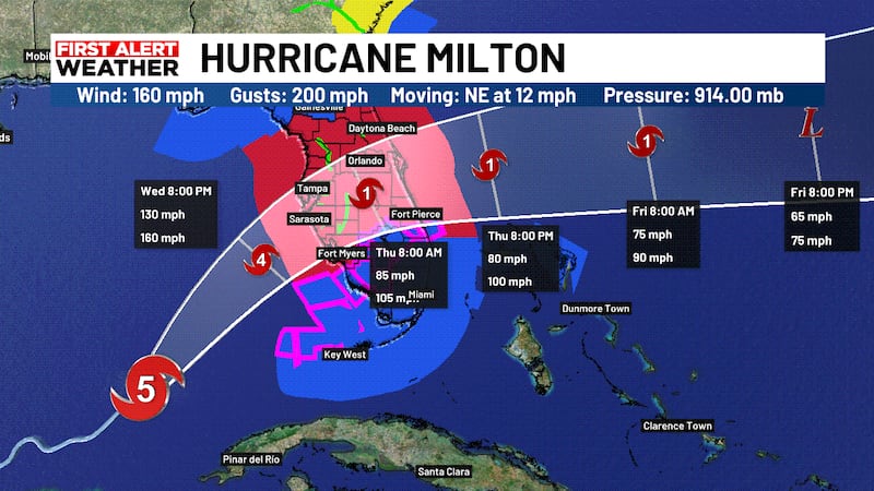
SARASOTA, Fla. (WWSB) - A northeastward motion with some increase in forward speed is expected through tonight. A turn toward the east-northeast and east is expected on Thursday and Friday. On the forecast track, the center of Milton will move across the eastern Gulf of Mexico today, make landfall along the west-central coast of Florida late tonight or early Thursday morning.
Maximum sustained winds are near 160 mph (260 km/h) with higher gusts. Milton is a category 5 hurricane on the Saffir-Simpson Hurricane Wind Scale. Fluctuations in intensity are likely while Milton moves across the eastern Gulf of Mexico, but Milton is expected to be a dangerous major hurricane when it reaches thewest-central coast of Florida.
Hurricane-force winds extend outward up to 30 miles (45 km) from the center and tropical-storm-force winds extend outward up to 140 miles. The combination of a dangerous storm surge and the tide will cause normally dry areas near the coast to be flooded by rising waters moving inland from the shoreline. The water could reach the following heights above ground somewhere in the indicated areas if the peak surge occurs at the time of high tide...
Egmont Key, FL to Boca Grande, FL...10-15 ft
- Tampa Bay...10-15 ft
- Anclote River, FL to Egmont Key, FL...9-13 ft
- Boca Grande, FL to Bonita Beach, FL...8-12 ft
- Charlotte Harbor...8-12 ft
- Bonita Beach, FL to Chokoloskee, FL...5-8 ft
- Aripeka, FL to Anclote River, FL...5-8 ft
- Chokoloskee, FL to Flamingo, FL...3-5 ft
- Sebastian Inlet, FL to Altamaha Sound, GA...3-5 ft
- Altamaha Sound, GA to Edisto Beach, SC...2-4 ft
- Suwannee River, FL to Aripeka, FL...2-4 ft
- Dry Tortugas...2-4 ft
- St. Johns River...2-4 ft
Rainfall amounts of 6 to 12 inches, with localized totals up to 18 inches, are expected across central to northern portions of the Florida Peninsula through Thursday. This rainfall brings the risk of catastrophic and life-threatening flash and urban flooding, along with moderate to major river flooding.
Copyright 2024 WWSB. All rights reserved.